Description and History of Site:-
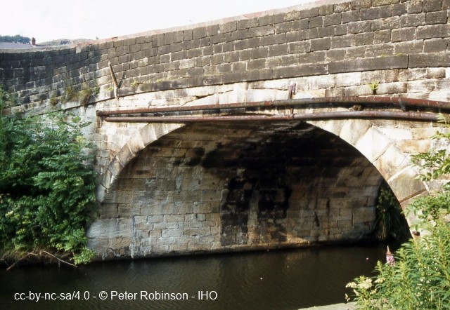
Hollins Bridge is a stone skew arched canal bridge employing stones laid in straight courses, but elongated to solve the problem of the skew. It is similar in design and date to the former Gorrell's Bridge, now demolished, which was the next bridge north-eastward of March Barn Bridge, near Castleton, on the Rochdale Canal (SD 88651 11044). March Barn Bridge, which links Gorrells Way with Gipsy Lane and Bow Street, employs winding courses to accommodate a skew of 60 degrees, and is a scheduled ancient monument. March Barn and Gorrell's have been said by R. Russell, 'to be probably the most significant engineering features on the canal'. Hollins Bridge has a slightly smaller degree of skew than March Barn, estimated at around 65 to 70 degrees, nevertheless, the loss of Gorrell's Bridge makes the survival of Hollins Bridge all the more important. Hollins Bridge is an early example of a stone skew bridge employing elongated stones within horizontal courses to overcome the skew. The Rochdale Canal was completed from Sowerby Bridge to Todmorden in August 1798 and to Rochdale in December of the same year, with through navigation to Manchester being achieved in 1804. There is good reason to believe that Hollins Bridge was the work of William Jessop the Superintendant Engineer of the Rochdale Canal, and was completed about the same time as Gorrell's Bridge near Rochdale, making it a significant engineering feature on the canal, all the more important since the destruction of Gorrell's prior to 1982. Jessop had built Shee or Scow (Skew) Bridge, just west of Robertstown, on the Grand Canal in Ireland during the early 1790s, only a few years after William Chapman's three skew bridges of 1787 (since demolished) on the adjoining County of Kildare Canal. Against the western abutment of the bridge, on the opposite bank to the towpath, is a milestone: S 11 1/2 M [20 1/2]. The latter mileage to Manchester is buried beneath the soil.
Further Reading and References:-Lost Canals of England and Wales, R.Russell, David & Charles, Newton Abbot, 1971, p. 201;
Lost Canals & Waterways of Britain, R. Russell, David & Charles, Newton Abbot, 1982, p. 228;
William Jessop, Engineer, C. Hadfield & A.W. Skempton, David & Charles, Newton Abbot, 1979, p. 31;
Civil Engineering Heritage, Northern England, R.W. Rennison, Thomas Telford Publishing. London, 2nd edition 1996, p. 236;
Civil Engineering Heritage, Ireland, R.C. Cox, & M.H. Gould, Thomas Telford Publishing, London, 1998, pp.108-9;
Rees's Manufacturing Industry (1819-20), volume 4, David & Charles Reprints, 1972, pp. 40-43.
Thanks are due to Adrian Wiszniewski for his assistance in calculating the angle of skew.
Help us improve this entry
The compilers welcome corrections or additional information on all sites.
Any information provided will be verified before appearing on the web site.
Email comments
Key Words :- canal road bridge skew arch stone
Viewing the Site :- The site is visble, both from Hollins Road and the towpath of the Rochdale Canal.
Address :- Hollins Road, Walsden, Todmorden, West Yorkshire, OL14 6QL
Grid Ref :- SD 93442 22106
Co-ordinates :- Lat 53.695354 , Long -2.100797
Local Authority :- Calderdale Council
Pre 1974 County :- Yorkshire - West Riding
Site Status :- Listed - Grade II
Historic England List No - 1229242,
Site Condition :- Operational site, in use for original purpose
Site Dates :- Pre December 1798 -
Record Date :- 5 December 2016
Copyright :- cc-by-nc-sa 4.0 © Peter Robinson